
Enabling Tourists to Visualize Regional Attractions Using Custom Esri ArcGIS ( Małopolska, Poland)
Overview
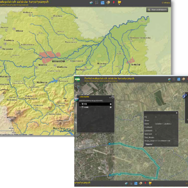
To establish a web-based mapping portal for the mountain tourism industry that enables portal users to plan and visualize routes based on the type of trip they desire and degree of difficulty (ex: hiking, skiing, equestrian).
The Impact
Visitors and end-users of the web mapping portal can visualize available tourist routes and recreation areas. Users can conduct spatial analysis of the terrain profile using the planned routes and identify distances, shortest paths, and tourist attractions.
The Outcome
GISonLine successfully built and deployed a web-based mapping portal in support of promoting tourism for the Małopolska province in Poland.
The mapping portal was established based on requirements to provide portal users with the ability to:
• Browse & search data on hiking trails and tourist attractions
• Perform spatial analysis on terrain profiles
• Calculate distances between points
• search for the shortest / fastest routes
• Add user comments and input


Client

Industry
Consumer Applications
Region
Europe
Technology
ArcGIS Server
ArcGIS Network Analyst
MS SQL Server
See some things
we've worked on


GRIDonLine is a comprehensive GIS Utilities Asset Management (AM) system designed to scale from small to large enterprise utility networks.


UTIL.Inspections is a cloud-based (SaaS) web mapping application designed specifically for viewing, integrating and collaborating on survey & inspection datasets.


The innovative UTIL.Investments platform is designed to address the needs of industries involved in the design and implementation of linear infrastructure projects.

Contact us
Looking for Location Intelligence?

