
GRIDonLine – implementation of graph-based network topology for comprehensive power grid modeling – PKP Power (Rail Energy)
Client: PKP Power (Rail Energy)
Location: Poland
The project to implement a network topology based on graph technology was part of a larger program – the transformation of PKP Power (a European utility provider) asset management processes using modern geospatial capabilities to support the supply, management, and delivery of electricity distribution for railway transportation.
The challenge was the implementation of a network topology in a modern, ESRI web-based solution in a time when the geometry network became legacy technology and the ESRI Utility Network was not mature enough to replace it. The customer urgently needed a working spatial network model to be able to fulfill business needs.
The Impact
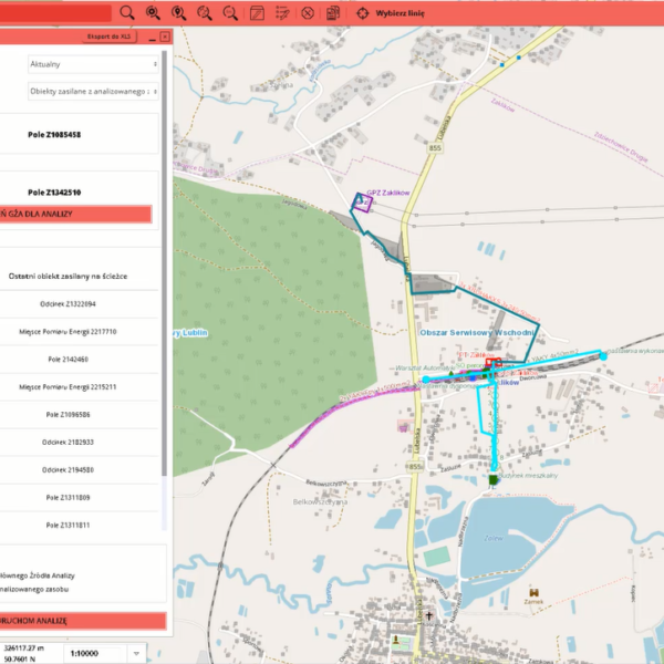
GISonLine implemented a system graph-based topology as a part of the GRIDonLine product, which is a custom ESRI ArcGIS enterprise mapping system of the inventory.
The custom service-based topology enabled advanced network analysis, vital for advanced business processes supporting infrastructure management.
The Outcome
GISonLine performed a successful digital transformation of the PKP Power asset management processes and a technology upgrade with the implementation of the GRIDonLine custom ESRI solution designed by GISonLine.
The GRIDonLine solution enhanced with graph-based network topology addressed the complexity of formalizing and managing the railway utility distribution networks.
With over 800 users connecting to the GRIDonLine platform, visualization of PKP Energetyka assets and their details can be communicated across the enterprise and managed via the centralized repository.


Client

Industry
Energy & Utilities
Region
Europe
Technology
ArcGIS Experience Builder
JavaScript, HTML, CSS
Esri ArcGIS Enterprise
Portal for ArcGIS
PostgreSQL


GRIDonLine is a comprehensive GIS Utilities Asset Management (AM) system designed to scale from small to large enterprise utility networks.


UTIL.Inspections is a cloud-based (SaaS) web mapping application designed specifically for viewing, integrating and collaborating on survey & inspection datasets.


The innovative UTIL.Investments platform is designed to address the needs of industries involved in the design and implementation of linear infrastructure projects.

Contact us
Looking for Location Intelligence?

