
Smarter Network Asset Management through GIS–EAM Integration
Overview
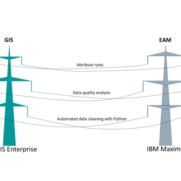
Northern Ireland Energy Networks (NIEN) embarked on a strategic initiative to strengthen its network asset management capabilities by integrating IBM Maximo Enterprise Asset Management (EAM) with ArcGIS Enterprise. The goal was to create a reliable, location-based view of network assets that supports operational excellence, regulatory requirements, and long-term grid modernization.
GISonLine, in partnership with Cohesive, delivered the integration concept, ensuring a scalable and future-proof architecture aligned with utility best practices and NIEN’s roadmap toward Utility Network adoption.
Impact
The GIS–EAM integration provides NIEN with immediate access to accurate asset locations and attributes directly within operational and maintenance workflows. Clear ownership of data between systems was established, along with defined synchronization rules and shared attributes critical for network operations.
This enables better planning, faster decision-making, and improved coordination between field, engineering, and asset management teams—while laying the groundwork for managing increasingly complex, distributed energy networks.
Outcome
NIEN now operates on a trusted, integrated data foundation that delivers a true “single version of the truth” for network assets. The solution improves data quality, reduces operational risk, and enhances readiness for advanced capabilities such as Utility Network, digital twins, and predictive maintenance.
By aligning GIS and EAM into one coherent ecosystem, NIEN is better equipped to ensure network reliability, support the energy transition, and meet the evolving expectations of modern utility operations.
Key Benefits
-
Single version of the truth – one trusted, integrated source of asset and spatial data across GIS and EAM systems.
-
Improved operational efficiency – faster access to accurate asset locations and attributes for maintenance, engineering, and planning teams.
-
Clear data ownership – well-defined responsibilities between GIS and EAM, reducing duplication and data inconsistencies.
-
Utility Network readiness – a solid foundation for advanced network modeling and connectivity-based analysis.
-
Reduced operational risk – higher data quality and consistency support safer, more reliable network operations.
-
Future-proof architecture – scalable integration supporting digital twins, predictive maintenance, and the energy transition.


Client
Industry
Energy & Utilities
Power Distribution Network
DSO
Region
Europe
Norther Ireland
Technology
ArcGIS Server
Rest
Python ArcPy
Maximo IBM
IBM Cron
GRIDonLine


GRIDonLine is a comprehensive GIS Utilities Asset Management (AM) system designed to scale from small to large enterprise utility networks.
UTIL.Inspections


UTIL.Inspections is a cloud-based (SaaS) web mapping application designed specifically for viewing, integrating and collaborating on survey & inspection datasets.
UTIL.Investments


The innovative UTIL.Investments platform is designed to address the needs of industries involved in the design and implementation of linear infrastructure projects.

Contact us
Looking for Location Intelligence?

